
Because field erodibility varies with field conditions, a procedure to solve WEQ for periods of less than one year was devised. In this procedure, a series of factor values are selected to describe successive management periods in which both management factors and vegetative covers are nearly constant. Erosive wind energy distribution is used to derive a weighted soil loss for each period. Soil loss for the management periods over a year are added to estimate annual erosion. Soil loss from the periods also can be added for a multi-year rotation, and the loss divided by the number of years to obtain an average, annual estimate.
WEQ is currently the most widely used method for assessing average annual
soil loss by wind from agricultural fields. The primary user of WEQ is the
Natural Resources Conservation Service (NRCS). When WEQ was developed
approximately 40 years ago, it was necessary to make it a simple mathematical
expression, readily solvable with the computational tools available. However,
WEQ has fundamental weaknesses because of its equation structures and its
empirical representation of erosion processes. Since its inception, there have
been a number of efforts to improve the accuracy, ease of application, and range
of WEQ. Despite efforts to make such improvements, the structure of WEQ
precludes adaptation to many problems.
The Wind Erosion Prediction System
Click here for more
detailed Overview of WEPS in Adobe Acrobat format
(you must have an Adobe Acrobat Reader installed for your WEB browser)
Wind erosion is a serious problem on agricultural lands throughout the United States as well as the world. The ability to accurately predict soil loss by wind is essential for, among other things, conservation planning, natural resource inventories, and reducing air pollution from wind blown sources.
The USDA appointed a team of scientists to take a leading role in combining the latest in wind erosion science and technology with databases and computers, to develop what should be a significant advancement in wind erosion prediction technology. The Wind Erosion Prediction System (WEPS) incorporates this new technology and is designed to be a replacement for WEQ.
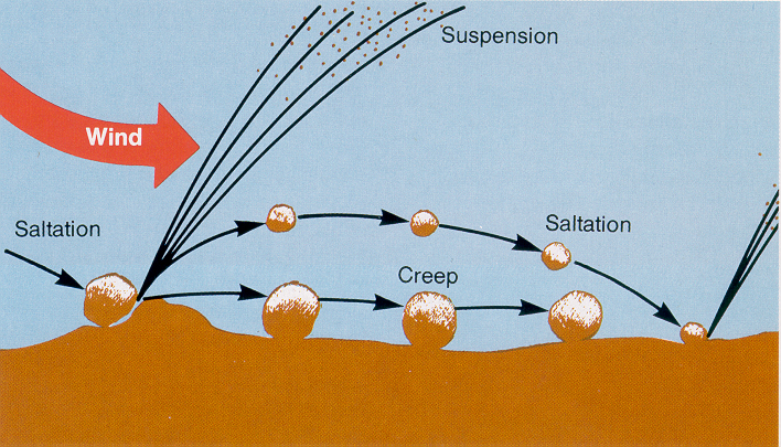
Unlike WEQ, WEPS is a process-based, continuous, daily time-step model that simulates weather, field conditions, and erosion. It is a user friendly program that has the capability of simulating spatial and temporal variability of field conditions and soil loss/deposition within a field. WEPS can also simulate complex field shapes, barriers not on the field boundaries, and complex topographies. The saltation, creep, suspension, and PM10 components of eroding materials can also be reported separately by direction in WEPS. WEPS is designed to be used under a wide range of conditions in the U.S. and easily adapted to other parts of the world.
Soil erosion by wind is initiated when wind speed exceeds the saltation threshold velocity for a given field condition. After initiation, the duration and severity of an erosion event depends on the wind speed distribution and the evolution of the surface condition. Because WEPS is a continuous, daily, time-step model, it simulates not only the basic wind erosion processes, but also the processes that modify a soil's susceptibility to wind erosion.
The structure of WEPS is modular and consists of a user-interface, a MAIN (supervisory) routine, seven submodels, and four databases. Most of the submodels within WEPS use daily weather (from the WEATHER submodel) as the natural driving force for the physical processes that change field conditions. The HYDROLOGY submodel accounts for changes in temperature and water status of the soil. Changes in the soil properties between management events are simulated in the SOIL submodel. The growth of crop plants is simulated in the CROP submodel, and their decomposition is accounted for in the DECOMPOSITION submodel. Step changes in the soil and biomass conditions generated from typical management practices such as tillage, planting, harvesting, and irrigation are modeled within the MANAGEMENT submodel of WEPS. Finally, the power of the wind on a subhourly basis is used to drive the EROSION submodel.
Click here for the
current version of the WEPS Technical Documentation
(you must have an Adobe Acrobat Reader installed for your WEB browser)
WEPS 1.5 User's Manual (pdf format) (you must have an Adobe Acrobat Reader installed for your WEB browser)