
Wind erosion is a serious problem on agricultural lands
throughout the United States as well as the world. The ability to
accurately predict soil loss by wind is essential for, among
other things, conservation planning, natural resource
inventories, and reducing air pollution from wind blown sources.
The USDA appointed a team of scientists to take a leading role in
combining the latest in wind erosion science and technology with
databases and computers, to develop what should be a significant
advancement in wind erosion prediction technology. The Wind
Erosion Prediction System (WEPS) incorporates this new technology
and is designed to be a replacement for WEQ.
Unlike WEQ, WEPS is a process-based, continuous, daily time-step
model that simulates weather, field conditions, and erosion. It
is a user friendly program that has the capability of simulating
spatial and temporal variability of field conditions and soil
loss/deposition within a field. WEPS can also simulate complex
field shapes, barriers not on the field boundaries, and complex
topographies. The saltation, creep, suspension, and PM10
components of eroding materials can also be reported separately
by direction in WEPS. WEPS is designed to be used under a wide
range of conditions in the U.S. and easily adapted to other parts
of the world.
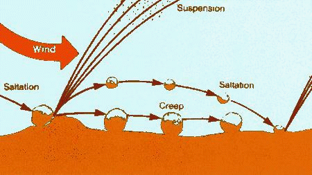
Soil erosion by wind is initiated when wind speed exceeds the
saltation threshold velocity for a given field condition. After
initiation, the duration and severity of an erosion event depends
on the wind speed distribution and the evolution of the surface
condition. Because WEPS is a continuous, daily, time-step model,
it simulates not only the basic wind erosion processes, but also
the processes that modify a soil's susceptibility to wind
erosion.
The structure of WEPS is modular and consists of a
user-interface, a MAIN (supervisory) routine, seven submodels,
and four databases. Most of the submodels within WEPS use daily
weather (from the WEATHER submodel) as the natural driving force
for the physical processes that change field conditions. The
HYDROLOGY submodel accounts for changes in temperature and water
status of the soil. Changes in the soil properties between
management events are simulated in the SOIL submodel. The growth
of crop plants is simulated in the CROP submodel, and their
decomposition is accounted for in the DECOMPOSITION submodel.
Step changes in the soil and biomass conditions generated from
typical management practices such as tillage, planting,
harvesting, and irrigation are modeled within the MANAGEMENT
submodel of WEPS. Finally, the power of the wind on a subhourly
basis is used to drive the EROSION submodel.
The Beta release contains the following:
This documentation specifically describes this Beta release. For general information about the WEPS system see the accompanying WEPS Technical Documentation which is available in PDF (Adobe Acrobat) formats:
http://www.weru.ksu.edu/weps/docs/weps_tech.pdf
Additional information is also available at the WEPS system website:
http://www.weru.ksu.edu/weps/
Note: Please read the Read This First files before using the release
Copyright 1998-1999 USDA ARS WERU.