An Overview of the Wind Erosion Prediction System
Introduction
The Wind Erosion Prediction System (WEPS) is a process-based, daily time-step
model that simulates weather, field conditions, and erosion. WEPS development
was in response to customer requests for improved wind erosion technology. It
is intended to replace the predominately empirical Wind Erosion Equation (WEQ)
(Woodruff and Siddoway, 1965) as a prediction tool for those who plan soil conservation
systems, conduct environmental planning, or assess offsite impacts caused by
wind erosion.
WEPS development involves an ARS-led, national, multidisciplinary team of scientists.
It has a multi-agency commitment consisting of the Agricultural Research Service
(ARS), Natural Resource Conservation Service (NRCS), and Forest Service (FS)
from the U.S. Department of Agriculture, along with the Environmental Protection
Agency (EPA), the U.S. Army Corps of Engineers, and Bureau of Land Management
(BLM).
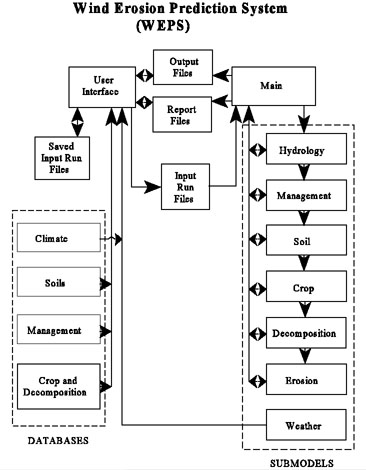
Figure 1.1. A structural diagram of the WEPS model.
Objectives
The purposes of WEPS are to improve assessment of soil loss by wind from agricultural
fields and to provide new capabilities such as assessing plant damage, calculating
suspension loss, and estimating PM-10 emissions from the field.
Background
Soil erosion by wind is initiated when the wind speed exceeds the saltation
threshold speed for a given soil and biomass condition. After initiation, the
duration and severity of an erosion event depend on the wind speed and the evolution
of the surface condition. Because WEPS is a continuous, daily time-step model,
it simulates not only the basic wind erosion processes, but also the processes
that modify a soil's susceptibility to wind erosion.
The structure of WEPS is modular and consists of a user-interface, a MAIN (supervisory)
routine, seven submodels, and four databases (Fig. 1.1). The user-interface
is used to create input files with information from the databases and the weather
generator. In a practical application, new input files usually will be created
by using previous input files as templates modified within the user-interface.
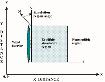
Figure 1.2. WEPS simulation geometries.
Simulation Region
In WEPS, the simulation region is a field (Fig. 1.2). Users must input the
geometry of the simulation region. Initial conditions must also be specified
for the surface and soil layers. WEPS can output soil loss/deposition over selected
time intervals from the simulation region. WEPS also provides users
with individual soil loss components of creep-saltation, suspension, and PM-10
size fractions. The soil loss components are particularly useful as an aid in
estimating off-site impacts of wind erosion.
Discrete Time and Space
The time step is controlled by the main program. To reduce computation time,
a daily time step is used in WEPS, except for selected subroutines in the HYDROLOGY
and EROSION submodels, which use hourly or subhourly time steps. Submodels are
called by the MAIN program (Tatarko, 1995) in the order shown in Fig. 1. Each
individual submodel controls the sequence of calculations within itself. However,
in MANAGEMENT, field operations are simulated sequentially according to the
order in which they appear in the management plan. Management plans usually
cover at least a single year and may cover multiple years. The management plan
can be initiated on any given day of the year, typically when there is no growing
crop. WEPS simulates conditions and soil loss on homogeneous simulation regions.
"Homogeneous" means that the soil type, biomass, and management are similar
over a subregion.
Weather Simulated from Climate Databases
WEPS requires wind speed and direction to simulate the process of soil erosion
by wind. These and other weather variables are needed to drive temporal changes
in hydrology, soil erodibility, crop growth, and residue decomposition in WEPS.
The weather generator consists of the programs WINDGEN and CLIGEN (Tatarko et
al., 1995).
WINDGEN simulates wind speed and direction for WEPS (Skidmore and Tatarko, 1990;
Wagner et al., 1992). It was developed specifically for use with WEPS and stochastically
simulates wind direction and subdaily wind speeds when needed. A compact database
(Skidmore and Tatarko, 1990, 1991) developed for WINDGEN was derived from
historical monthly summaries of wind speed and wind direction contained in the
Wind Energy Resource Information System (WERIS) database at the National Climatic
Data Center in Asheville, North Carolina.
CLIGEN is the weather generator developed for the Water Erosion Prediction
Project (WEPP) erosion model (Nicks et al., 1987). It is used with WEPS to generate
an average annual air temperature as well as daily precipitation, maximum and
minimum temperatures, solar radiation, and dew point temperature. Average daily
air temperature and elevation for the site are used to calculate average daily
air density within WEPS. CLIGEN and its database are described fully in the
WEPP documentation (Nicks and Lane, 1989).
Field Conditions Simulated
The HYDROLOGY submodel (Durar and Skidmore, 1995) estimates soil surface wetness;
accounts for changes in soil temperature; and maintains a soil-water balance
based on daily amounts of snow melt, runoff, infiltration, deep percolation,
soil evaporation, and plant transpiration. Snow melt depends on maximum daily
air temperature and initial snow water content. Runoff is calculated from rainfall
rate greater than infiltration, adjusted for ponding and surface flow velocity.
Water is infiltrated and distributed according to Darcy's Law. Potential evapotranspiration
is calculated using a revised combination method of Van Bavel. Total daily potential
evapotranspiration then is partitioned, based on crop leaf area index, into
potential soil evaporation and plant transpiration. Hourly potential soil evaporation
rates are estimated from the daily value based on soil water availability.
A soil's aggregation and surface state can dramatically affect susceptibility
to wind erosion. Thus, changes in soil and surface temporal properties are simulated
daily by the WEPS SOIL submodel (Hagen et al., 1995b) in response to various
weather processes like wetting/drying, freeze/drying, freeze/thawing, precipitation
amount and intensity, and time. Soil layer properties such as bulk density,
aggregate size distribution, and dry aggregate density are maintained on a daily
basis. Surface properties, such as random and oriented roughness, crust generation,
coverage fraction, density, stability, and thickness, and loose erodible material
on crusted surfaces also are accounted for in the SOIL submodel.
The presence of live biomass on the soil surface influences the quantity of
soil that can be removed by wind erosion. Therefore, the CROP submodel (Retta
and Armbrust, 1995) simulates the growth of crop plants. The crop growth model
was adapted from the Erosion Productivity Calculator (EPIC) crop growth model
(Williams et al., 1990), which simulates a variety of crops and plant communities
while accounting for water stresses.
It calculates daily production of masses of roots, leaves, stems, and reproductive
organs and also leaf and stem areas. Additional capabilities and modifications
have been incorporated into the CROP submodel to meet the need for predicting
effects of a growing crop on wind erosion. Some of the factors that affect wind
erosion are the flexibility and arrangement of individual plant parts, distribution
of plant parts by height, and number of plants per unit area (Shaw and Periera,
1982). Thus, leaves and stems are accounted for separately because: 1) stems
of young seedlings are roughly 10 times more effective than leaves, on a per-unit-area
basis, in depleting wind energy; 2) leaves are more sensitive to sandblast damage
than are stems; and 3) decomposition rates of stems and leaves are different.
The DECOMPOSITION submodel (Steiner et al., 1995) for WEPS simulates the decrease
in crop residue biomass from microbial activity. The decomposition process is
modeled as a first order reaction, with temperature and moisture as driving
variables. Standing residue is significantly more effective than flat residue
at reducing wind energy at the soil surface. Hence, it is maintained separately
from flat residue, and the conversion from standing to flat is simulated. The
quantities of biomass remaining after harvest are partitioned into standing,
surface, buried, and root pools with belowground biomass decomposition calculated
for each soil layer. Because crop residue decomposition varies by type and changes
with residue age, each pool is subdivided further into 1) the most recently
harvested crop pool, 2) the penultimate crop pool, and 3) a "generic" crop pool
that contains all older residue mass.
WEPS is expected to reflect the effects of various management practices upon
wind erosion, and that is done by the MANAGEMENT submodel (Wagner and Ding,
1995). All major management operation classes are represented, such as primary
and secondary tillage, cultivation, planting/seeding, harvesting, irrigation,
fertilization, grazing, and burning. Each individual operation is simulated
within the MANAGEMENT submodel as a series of physical processes. Those processes
include 1) soil mass manipulation (changes in aggregate size distribution, soil
porosity, mixing soil and residue by depth, and soil layer inversion); 2) surface
modification (creation or destruction of ridges and/or dikes that form oriented
surface roughness, changes in surface random roughness, and destruction of surface
crusts); 3) biomass manipulation (burying and resurfacing residue, cutting standing
residue, flattening standing residue, killing live crop biomass, and biomass
removal); and 4) soil amendments (fertilization (not available in WEPS),
planting, and irrigation).
Erosion Processes Simulated
The EROSION submodel (Hagen, 1995) decides if erosion can occur based on the
current soil surface roughness (oriented and random), flat and standing biomass,
aggregate size distribution, crust and rock cover, loose erodible material on
a crust, and soil surface wetness. If the maximum daily wind speed reaches 8
m/s at 10m and snow depth is less than 20mm, the surface condition is evaluated
on a subhourly basis to determine if erosion can occur. The EROSION submodel
simulation performs the following functions: 1) calculates friction velocities
based on the aerodynamic roughness of the surface, 2) calculates static threshold
friction velocities, 3) computes soil loss/deposition within each grid cell,
and 4) updates soil surface variables to reflect changes in soil surface "state"
caused by erosion.
Summary Comparison of WEPS and WEQ
Users of wind erosion prediction technology encounter a wide range of challenging
environmental problems that require solutions. WEQ was unable to meet some of
these needs. After extensive consultations with users, the WEPS structure was
designed with the capabilities to meet the needs identified. As such, WEPS represents
new technology and is not merely an improvement and recoding of WEQ technology.
Also, WEPS contains many simplifications to maintain reasonable computation
times. Because many users are familiar with WEQ, a brief comparison of WEPS
and WEQ follows to facilitate understanding of WEPS modeling techniques.
WEQ predicts average erosion along line-transects across the field, whereas
WEPS treats the field as two-dimensional. The WEPS EROSION submodel simulates
soil loss/deposition for grid areas over the entire simulation region. This
feature allows users to "look inside" by specifying arbitrary accounting regions
within the simulation region and, thus, obtain results averaged over selected
grid areas within the accounting region (not available in WEPS).
WEQ predicts only long-term, average, soil loss. WEPS calculates on a daily
basis and allows users to specify the output intervals. Thus, users can obtain
outputs ranging from single storms to multiple years. By simulating for multiple
years, the probability of various levels of erosion during any period of the
rotation also can be determined.
The largest contrast between the two technologies is that WEPS simulates a
wide range of processes to describe field surface conditions and wind erosion,
whereas WEQ depends on users to input correct estimates of the field surface
conditions. Unfortunately, erosion does not vary linearly with residue cover
and other temporal field conditions. Therefore, simply specifying average field
conditions as inputs likely will not yield the best estimates of long-term average
erosion.
The WEQ contains no feedback loop that modifies the field in response to weather
or erosion. In WEPS, the driving forces of weather cause surface temporal properties
of the field to change. Thus, in a year with high rainfall, the field soil roughness
may be reduced below average, while above average biomass production prevents
erosion. However, in a drought year, biomass and aggregate size may both be
below average, but tillage ridges may then be the primary control against soil
erosion.
The modeling techniques used to simulate processes in WEPS vary. The WEATHER
submodel generates stochastic simulated weather variables. Mechanistic and statistical
relations are used to represent processes in the other submodels.
However, a structured design methodology was used. First, the major wind erosion
processes, such as emission, abrasion, and trapping were identified. Next, the
individual temporal soil and biomass properties that affect the wind erosion
processes were selected. Then, WEPS submodels were designed to simulate the
general processes that control both the surface temporal properties and the
erosion processes. Finally, parameters from the databases were used to make
the simulation of various processes unique for specific soil, crop, and management
actions.
Implementation
The current WEPS model is coded in FORTRAN conforming to the ANSI FORTRAN 77
and Fortran 95 standard. The coding guidelines used, with some minor modifications
for WEPS, are outlined in the "Water Erosion Prediction Project (WEPP) Fortran-77
Coding Convention" (Carey et al., 1989). The model can be run in both a Windows,
Linux, or Unix environment. WEPS science code and implementation is documented fully
in the WEPS Technical Description (Hagen et al., 1995a).
WEPS Updates
The WEPS model is continually being improved with periodic updates. The USDA-ARS
Wind Erosion Research Unit (WERU) has established several means for obtaining
the latest release of the WEPS model, databases, documents, and other related
information as they become available.
For users with Internet access, WERU has established a World Wide Web site.
The URL for WEPS downloads is: http://weru.ksu.edu/weps. This site contains
all the information WEPS. Specific WEPS information also can be obtained through
E-Mail at: weps@weru.ksu.edu .
Users without Internet access can obtain WEPS update information by contacting:
USDA-ARS, NPA
Wind Erosion Research Unit
Throckmorton Hall
Kansas State University
Manhattan, KS 66506
Phone: 785-532-6495 FAX: 785-532-6528
References
Carey, W., T. Elledge, D. Flanagan, E. Night, O. Lee, C. Meyer, and P.Swetik.
1989. Water Erosion Prediction Project (WEPP) Fortran-77 coding convention.
Draft.
Durar, A.A. and E.L. Skidmore. 1995. WEPS technical documentation: hydrology
submodel. SWCS WEPP/WEPS Symposium. Ankeny, IA.
Hagen, L.J. 1995. WEPS technical documentation: erosion submodel. SWCS WEPP/WEPS
Symposium. Ankeny, IA.
Hagen, L.J., L.E. Wagner and J. Tatarko.. 1995a. WEPS technical documentation:
introduction. SWCS WEPP/WEPS Symposium. Ankeny, IA.
Hagen, L.J., T.M. Zobeck, E.L. Skidmore, and I. Elminyawi. 1995b. WEPS technical
documentation: soil submodel. SWCS WEPP/WEPS Symposium. Ankeny, IA.
Nicks, A.D., J.R. Williams, C.W. Richardson, and L.J. Lane. 1987. Generating
climatic data for a water erosion prediction model. ASAE, Paper No. 87-2541.
St. Joseph, MI 49085-9659.
Nicks, A.D. and L.J. Jane. 1989. Weather generator, pp 2.1-2.19. In L.J. Lane
and M.A. Nearing (editors), USDA -Water erosion prediction project: Hillslope
profile model documentation. NSERL Report No. 2, USDA-ARS, National Soil Erosion
Research Laboratory, West Lafayette, IN 47907.
Retta, A. and D.V. Armbrust.. 1995. WEPS technical documentation: crop submodel.
SWCS WEPP/WEPS Symposium. Ankeny, IA.
Shaw, R.H., and A.R. Periera. 1982. Aerodynamic roughness of a plant canopy:
A numerical experiment. Agric. Meteorol. 26:51-65.
Skidmore, E.L. and J. Tatarko. 1990. Stochastic wind simulation for erosion
modeling. Trans. ASAE 33:1893-1899.
Skidmore, E.L. and J. Tatarko. 1991. Wind in the Great Plains: speed and direction
distributions by month. Pages 245-263 In: J.D. Hanson, M.J. Shaffer, and C.V.
Cole (eds.) Sustainable Agriculture for the Great Plains, USDA-ARS, ARS-89.
Steiner, J.L., H.H. Schomberg, and P.W. Unger. 1995. WEPS technical documentation:
residue decomposition submodel. SWCS WEPP/WEPS Symposium. Ankeny, IA.
Tatarko, J. 1995. WEPS technical documentation: main program. SWCS WEPP/WEPS
Symposium. Ankeny, IA.
Tatarko, J., E.L. Skidmore,. and L.E. Wagner. 1995. WEPS technical documentation:
weather submodel. SWCS WEPP/WEPS Symposium. Ankeny, IA.
Wagner, L.E., and D. Ding. 1995. WEPS technical documentation: management submodel.
SWCS WEPP/WEPS Symposium. Ankeny, IA.
Wagner, L.E., J. Tatarko, and E.L. Skidmore. 1992. WIND_GEN - Wind data statistical
database and generator. ASAE, Paper No. 92-2111. St. Joseph, MI 49085-9659.
Williams, J.R., C.A., Jones, and P.T. Dyke. 1990. The EPIC Model. An Erosion/Productivity
Impact Calculator: 1. Model Documentation. eds. A.N. Sharply and J.R. Williams.
USDA Tech. Bulletin No. 1768.l 235pp.
Woodruff, N.P. and F.H. Siddoway. 1965. A wind erosion equation. Soil Sci.
Soc. Am. Proc. 29(5):602-608.