How to Operate Soil
Choosing a Soil
A soil for a simulation run is selected using the 'Soil' box on the right
side of the bottom panel of the WEPS1.0 main screen.

The soil for a simulation run can be selected from the NRCS SSURGO database by
clicking the 'Template' folder  to the left of the soil name.
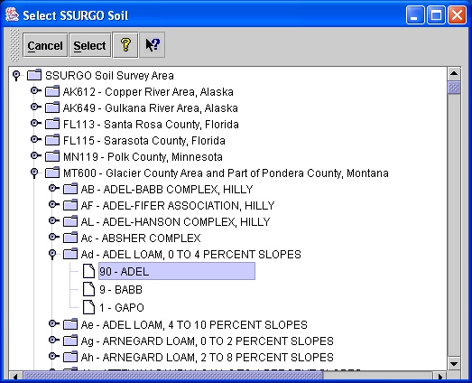
Clicking on the 'Template' folder opens a window titled 'Select SSURGO Soil' (see figure above).
Navigate through the database tree to find the soil survey area (or county) desired.
Navigation is performed by clicking on the 'key' symbol  to open the display to the next
level of the tree. To close a level of the tree, click the 'key' symbol
to open the display to the next
level of the tree. To close a level of the tree, click the 'key' symbol  to close. The soil
files are listed according to the soil map unit symbol, map unit name, surface texture, and
local phase. Selecting a soil then lists its components and the percent each component
contributes to the map unit. Click a soil component to highlight it and click the 'Select'
button
to close. The soil
files are listed according to the soil map unit symbol, map unit name, surface texture, and
local phase. Selecting a soil then lists its components and the percent each component
contributes to the map unit. Click a soil component to highlight it and click the 'Select'
button  at the top of the screen (or double click the component with the left mouse button).
This action converts the soil from the SSURGO database to a WEPS soil file format (with an
'ifc' extension) and returns the user to the main screen. The loaded soil file name will
appear in the soil box window. Clicking the 'Cancel' button
at the top of the screen (or double click the component with the left mouse button).
This action converts the soil from the SSURGO database to a WEPS soil file format (with an
'ifc' extension) and returns the user to the main screen. The loaded soil file name will
appear in the soil box window. Clicking the 'Cancel' button  on the 'Select SSURGO Soil'
window aborts the selection of a
new soil. The 'Question' button
on the 'Select SSURGO Soil'
window aborts the selection of a
new soil. The 'Question' button  opens the general help system for WEPS. The 'Context Help' button
  provides help for a particular item on the toolbar of the 'Select SSURGO Soil' screen.
Clicking the 'Context Help' button and then clicking on an item on the toolbar displays a
help screen for that item.
provides help for a particular item on the toolbar of the 'Select SSURGO Soil' screen.
Clicking the 'Context Help' button and then clicking on an item on the toolbar displays a
help screen for that item.
Soils that have been previously loaded to projects or modified and saved to another name can be opened by
clicking on the 'Project' folder  . This will open a window where
the user can select the desired soil or type in the soil file name.
. This will open a window where
the user can select the desired soil or type in the soil file name.
Users have the option to view the soil data by double clicking on the button labeled 'Soil', on the left
side of the soil box. This will open the WEPS Soil User Interface screen, which allows the user
to view, edit (disabled for NRCS), and save the soil information under a new file name under the project.